Short-Range
Numerical Weather Prediction Models
(red dot indicates preferred
model)
______________________________________________________________________
Tabular
NGM and ETA FOUS Output
RUC ETA ETA
06z ETA
18z NGM GFS-5
RGEM SREF MM5 CRAS UKMET. COAMPS BAMex
Mike
Sager's Weather Forecast Model Animator
______________________________________________________________________
Online Weather Information
Guides
WW2010
Helper Section Index
Weather
Calculator
COMET
Case Study Library on the WWW
Index
Of Storm Tracks
Climatology
Climate
Normals For The U.S.
Oscillations
And Climatic Teleconnections
Weather
Information Plotting/Mapping
Plymouth
State Weather Center
U.S. National Satellite
Perspectives
Infrared
Visible
Vapor
Hawaii
Infrared Hawaii
Visible
Alaska
Infrared Alaska
Visible Alaska
Vapor
Canada Satellite
Perspectives
Environment
Canada Satellite Image Directory
Satellite Animations And
Multi-Channel Imagery
RAMSDIS
ONLINE
NOAA Polar Satellite Views
Around North America
Quicklook
Swaths Browser
AVHRR Dynamic
Tracking Windows
Milan
Konecny's NOAA Satellite Views
WTOC-TV
HRPT Images
National Radar Summaries
National
NEXRAD Composite
Environment
Canada Radar Summary
Numerical Model Temperature
Forecasts
Current
NWS MOS Forecast Products
Links To Current Weather
Conditions
Around North America
Current
Weather Observations
National
Data Buoy Center
Solar, Lunar, Astronomy
Information
MeL:
Space & Astronomy
SpaceWeather.Com
Tonight's
Sky Sky
& Telescope Interactive Sky Chart
Human
Space Flight - NASA-TV Solar Terrestrial Activity
Report
Satellite-Derived Forecast
Products
NOAA/NESDIS/ORA
Forecast Products
Upper Air Analyses Around North America
Upper Air Data
From University Of Wyoming Canada
ETA Soundings
Aviation Weather Analyses
And Forecasts
Soundings
from Commercial Airliners
Aviation Weather
Center (AWC)
Clear
Air Turbulence Index Forecasts
Current Icing
Potential (CIP)
ADDS
- Turbulence
Environment
Canada Aviation Products
National
Soil Moisture Levels
Palmer
Index Map (For Soil Moisture)
Drought
Monitor
______________________________________________________________________
National
Thunderstorm Potential Forecast Models
Oklahoma
University Daily Real Time Analysis And Forecast System
Experimental
0-3 Hour Convective Weather Forecast Products
National
Convective Weather Forecast Product
Collaborative
Convective Forecast Product
Environment
Canada Severe Weather Model
Severe
Weather Watch Boxes
SPC
Watch, Warning and Advisory Display
Local Weather Warnings
College Of DuPage Severe Weather
Warnings Page
U.S.
Station Weather Probability Forecasts
_____________________________________________________________
READY
Quick Meteogram
ETA MOS
Graphics
NGM MOS
Graphics
MET MOS
Graphics
Form
For Selecting AVN MOS Bulletins
______________________________________________________________________
Visible, Infrared, And
Water Vapor
Close-Up Satellite Views:
College
Of Dupage Regional Satellite Bar
IPS Meteostar Regional Radar
Summaries
Northeast Southeast North
Central
South
Central Northwest Southwest
Useful Television Station
And Commercial
Doppler Radar Sites
WeatherMatrix
Radar Supersite : TV Radars
Doppler Radar Images From
Government Sources
National
Weather Service Doppler Radars
Environment
Canada Doppler Radars
National Lightning
Detection Map
LightningStorm.com
| Free Lightning Explorer
Local Lightning Detection
Sites
_____________________________________________________________
AZ Mesa Kitts Peak
CO Castle
Rock
TX Taylor Bergheim Houston Irving Coppell
MN St.
Cloud Minneapolis Tracy Gunflint
Lake WI Madison
IA Cedar
Rapids MO Kansas
City Lebanon Ballwin Dardenne
Prairie
IL Grayville IN Kokomo MI Grand Rapids Clinton
KY Owensboro Danville
TN Cookeville AR Jonesboro
MS Vicksburg AL
Tuscaloosa Clay
GA Atlanta Marietta Monroe Savannah
FL Fort
Lauderdale Orlando St.
Petersburg Sarasota
NC Concord Greenville Little
Switzerland Asheville
VA Wallops
Island Yorktown Kilmarnock
PA State
College Reading Westtown
NJ Cherry
Hill Blackwood Highlands
LI NY Babylon
CT Voluntown New
London RI Charlestown
MA Rockland Norton Pittsfield
OH Randolph Mansfield Waynesville Columbus
ONT Fergus MB Whyte Ridge AB
Edmonton BC
Cranbrook
MEXICO Cuervos,
Monterrey
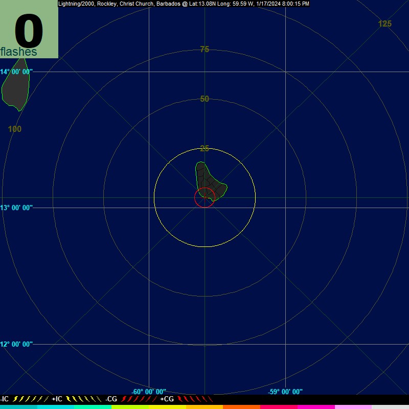
BARBADOS Worthing VIRGIN
ISLANDS St.
Croix
_____________________________________________________________
Media Resources, Online Mapping And Travel Aids
Kevin
Brewster Storm Spotting Frequencies Page
TV
Station Web Page Directory
Radio-Locator
National
Traffic and Road Closure Information
EarthaMaps MapQuest Maporama
Microsoft
TerraServer
The
National Atlas of the United States of America
Where
On Earth - Latitude Longitude Finder
Medium
Range Numerical Weather Prediction Models
(red dot indicates preferred
model)
______________________________________________________________________
GFS GFS
06z GFS
18z GFSX. UKMETx. ECMWF.
NOGAPS GGEM MM5x EtaXX
DAVA RSM JMA KMA CPTEC
FSU
SuperEnsemble GBL
Ensembles
NCEP
AVN-GFS Ensembles EPS
Maps NOGAPS
Ensembles
Form
For Selecting MRF MOS Bulletins
______________________________________________________________________
Worldwide
and International Satellite Images
Earth
Viewer: View Any Location from Any Satellite
______________________________________________________
GOES 12
(The Americas, Atlantic Ocean)
Visible Infrared Vapor
______________________________________________________
GOES 10
(Eastern Pacific Ocean)
Visible Infrared Vapor
______________________________________________________
GMS 5
(Asia, Australia, Pacific Ocean)
Visible Infrared Vapor
______________________________________________________
METEOSAT
5 (Central Asia)
Visible Infrared Vapor
______________________________________________________
METEOSAT
7 (Europe And Africa)
Visible Infrared Vapor
______________________________________________________
Arctic
Sea
Europe
Infrared Europe
Visible Europe
Vapor
Russia The
Middle East The
Orient India
Australia New
Zealand South
America Africa
Antarctica
______________________________________________________________________
International Weather Radar
Sites
WeatherMatrix
Radar Supersite : World Radar Data
Domestic And International
Weather Cameras
Web
Cams Of The World
TROPICAL WEATHER OUTLOOK
(monitoring tropical or subtropical disturbances in the oceanic
theaters of the northern hemisphere)
A check of satellite images of
the Caribbean
Sea shows the remnant circulation of
Tropical Depression 2, but with minimal convection. Southwest
flow aloft has now extended from just above the shoreline of
Venezuela into the Grand Banks. And with Hurricane Alex supplying
the impetus for development of a very rare, full-latitude trough
over eastern North America, it appears unlikely that TD 2 can
regenerate. As for other perturbations on the ITCZ coming off the
coast of western Africa, none appear likely to intensify into
tropical cyclones.
Tropical Numerical Weather
Prediction Models
Atlantic
Basin System NHC Models
Experimental
Forecast Tropical Cyclone Genesis Potential Fields
Maximum
Potential Hurricane Intensity
Satellite Images Of
Individual Tropical Systems
NRL
Monterey Tropical Cyclone Page
NOAA
GOES-EAST IMAGES and LOOPS
QuikSCAT
Storm Images
Satellite Images Of
Tropical Regions
GHCC
- Interactive GOES-8 Infrared Hurricane Sector
Equatorial
Atlantic Ocean
Mexico
And Pacific Coastal Waters
Central
Pacific Ocean
Oceania
And Tropical Western Pacific Ocean
Indian
Ocean
Sea Surface Temperatures
NODC Coastal Water
Temperature Guide
Great Lakes Sea
Grant Coastwatch Homepage
Global
Sea Surface Temperatures
Global
Sea Surface Temperature Anomaly
Global
Sea Surface Temperature Climatology
Marine Weather Information
WWW
Tide/Current Predictor - Site Selection
Office of Coast
Survey - Home - Nautical Charts
Regional Ocean
Forecast System (ROFS)
NOAA/NCEP
WAM Global Swell Data
Environment
Canada Ocean Wave Forecasts
NOAA
WAVEWATCH III Wave Models (interactive)
Great
Lakes Water Levels